

CVA 113-5 – North side False Creek looking east from Park Lane. April 1913. This is the only photo identified by CVA as being of or from Park Lane.
Park Lane was one of the early residential districts in Vancouver; it later was a proposed ‘red light’ district; the homes of the Lane were destroyed to help make way for the Union railway depot; the depot ultimately also succumbed to the wrecker; and it is set to become the site of the new St. Paul’s Hospital within a few years.
Like Mayfair, London?
According to Vancouver’s first archivist, J. S. Matthews, Park Lane was originally a fashionable residential district in early Vancouver — hence the swish name after the street in the Mayfair district in London, England.¹
“Wait,” I can hear you muttering. “Where was this fancy lane?”
Would you believe it was a single block stretch just east of Westminster Ave (behind what is now the 1000 block of Main St, between Prior St at the north and what is today known as National Ave. at its southern extreme? The residential dwellings were located principally on the east side of Park Lane (which is now called Station Street). This meant that the homes had a water view. And, according to Matthews, they also had ready access to a lovely beach.²
“Hold on,” you interject. “This is too much! A water view and a nice beach?! This is the block behind the Ivanhoe Hotel, isn’t it? That’s nowhere near any water!”
Nope, you’re quite right. Nowhere near water since ca1914, when this part of False Creek was filled in with land that was formerly part of the “Grandview Cut”. But we are getting ahead of ourselves.
Here is a map to help you get your bearings in the very different pre-1914 landscape that included Park Lane.

Vancouver Fire Insurance Map Book. Dakin Publishing Co., San Francisco: November 1889. UBC Rare Book Room (not available online).
You will notice on this very early fire insurance map that “Park Lane” was identified as “Park Ave.” This is the name used in the 1890 city directory, too. It was changed to “Park Lane” by 1892, however, and remained so until the City officially changed the name of the street to Station Street in 1926 (quite some time after the first train left Union station in 1918).
I wish there were photos of Park Lane which I could include to give some sense of the homes that made up the neighbourhood. But I haven’t been able to find any. The closest I could come (with thanks to Robert) was the drawn map shown below (1898).

CVA – Crop of Map 547 – Panoramic view of City of Vancouver, 1898. Vancouver World. Annotations are the author’s.

My impression from reading classified ads in editions of the Vancouver Daily World from the 1890s and early 1900s (advertising homes for sale or rent along the Lane), is that there was quite a variety of homes along the lane. Everything from “shacks” to a 9-room (Victorian-style?) home — complete with wharf extending into False Creek.
NIMBY to NIMMP (Not in my Mount Pleasant!)
Life along Park Lane seemed to proceed normally until 1906. That was the year that City Council decided to get into the moving business. Not furniture moving, mind you: people moving!
Until this time, prostitution in Vancouver was kept to E. Pender St. (called Dupont, at that time); this was known as the “restricted district” (what we’d call these days, the “red light district”). From what I can discern, prostitution at the time was not principally a street-walking occupation. It was, if you’ll pardon the expression, more of a “cottage industry” — carried on within dwellings (aka, brothels).
So, the City decided to move the ladies of E. Pender elsewhere. But why? There was very little attention paid to this (to me, obvious) question in press accounts of the time. Which leads me to believe that the answer was believed at the time to be self-evident. That led me to the conclusion that it was the usual reason: money (and in Vancouver, that has always meant the same thing as real estate values). I suspect that the value of real estate in E. Pender had risen recently and that led the city to kick out those who were not likely to be contributors to further escalation.
Whatever the reason(s) why the ladies weren’t allowed to remain on E. Pender, they were being told to move to the new restricted district.
Guess where?
Yup, Park Lane.
A brief public furore ensued upon the city’s decision to move the ladies to the Lane. The owners and residents of Park Lane didn’t seem to object to the City’s proposal. (Or if some of them did, they didn’t make loud noises about their concerns).
The main source of the loudest concern seemed to come from another neighbourhood: Mount Pleasant. Mount Pleasant was just across the Westminster (Main St) Bridge from the Lane and, so, just a few minutes away from the Lane by horse (or a few minutes more by shanks mare). What were the concerns of the denizens of Mount Pleasant?
- Those who were making the loudest noises believed that prostitution generally was a social evil and that the ladies ought not be welcomed in Vancouver anywhere.
- But if the ladies must be somewhere within the city, they certainly shouldn’t be in Park Lane. The reason: Park Lane was just off Westminster/Main, the bridge of which at the time was really the only means of easy access between Mount Pleasant and downtown.
- Therefore, the major motive of those in Mount Pleasant whose knickers were in a twist over the re-location of the ladies to Park Lane was not greatly different from those who wanted them out of E. Pender: Money (or, what amounts to the same thing, “trade”). Mount Pleasant residents were afraid that the presence of this “moral depravity” just on the other side of the Westminster Bridge would serve to reduce the quality and quantity of trade that made its way up to Mount Pleasant.
According to this site, the noise-makers were effective in getting the City to change its policy regarding the move of the restricted district. It would remain in the E. Pender vicinity for the time being; however it would move off that actual street to Canton and Shanghai Alleys.
In any case, Park Lane had a very limited lifespan going forward.
Goodbye Park Lane
Park Lane residents had just a few years from the proposed move of the restricted district before their homes had a date with the wrecking ball.
By 1912, the City of Vancouver had a deal with the Great Northern Railway (and Northern Pacific) that involved the GNR infilling part of False Creek and then establishing a Union depot on the infill (later, Canadian Northern Railway would do likewise just south of Union station; the CNR station is now known as the Pacific Central Station).
Infill and depot construction was underway by 1914, and the first train to leave the completed Union station (Fred Townley, architect) was a Northern Pacific train on January 1918. By 1965, Union Depot had evidently served its purpose; it, too was demolished.
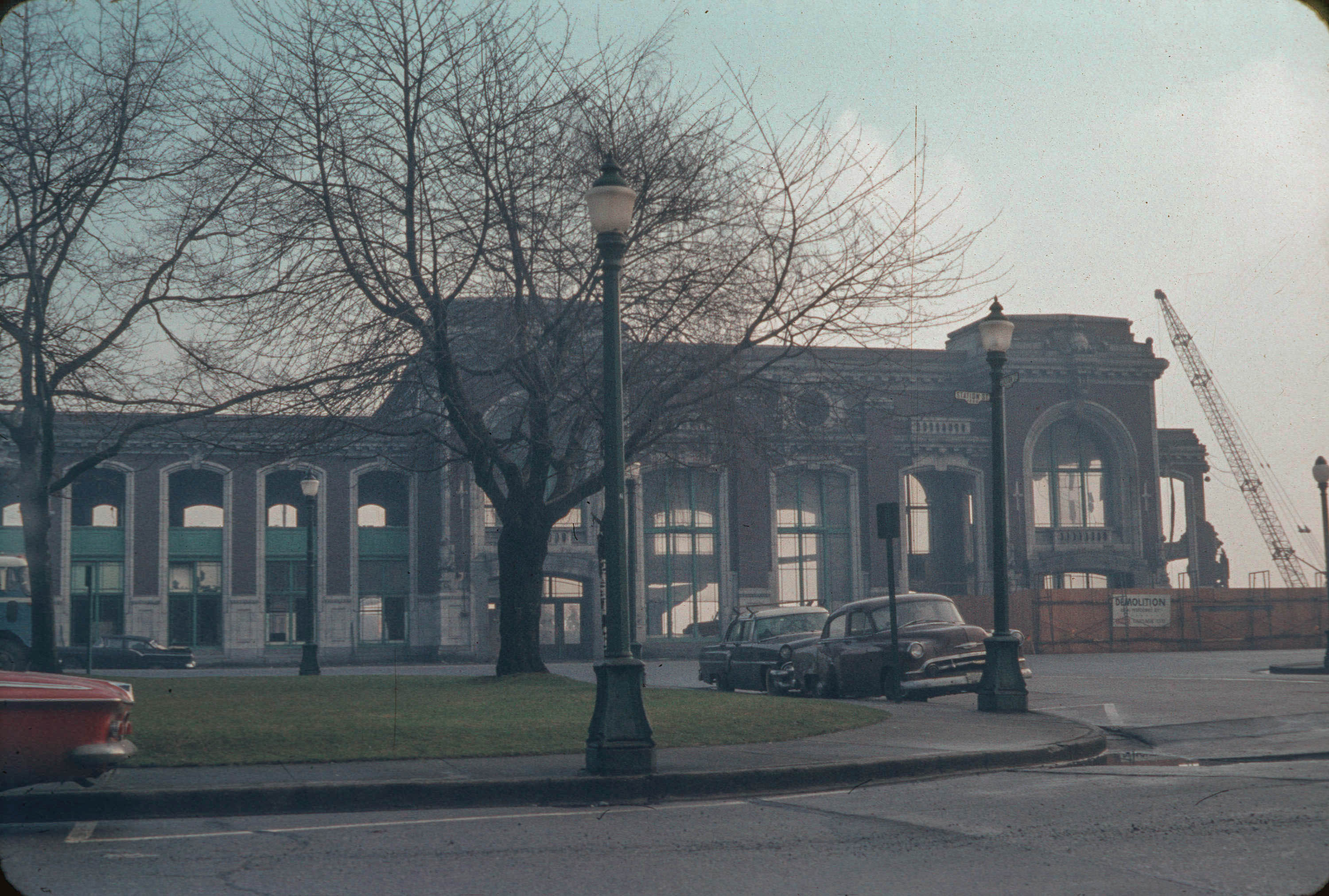
2010-006.103 – Wrecking Great Northern Depot – Vancouver Feb 1965. Ernie H. Reksten. The photographer would have been standing with his back to (and parallel with) Park Lane for this photo.

2010-006.104 – Great Northern Depot. 1965. Ernie H Reksten. This photo was made from a more oblique angle (toward the south – closer to the (then) CNR Depot. Union Depot’s freight sheds are visible running roughly perpendicular with the depot.
Since the demolition of Union depot, the land has been largely neglected. In recent years, it seems to have been used as a surplus lot for automobile dealers.
But plans are afoot for the former Park Lane and its waterfront. St. Paul’s Hospital will move to this site by about 2024.
Notes
¹Elizabeth Walker. Street Names of Vancouver. p. 116
²Walker, p. 116.

Great work! A sad end to the station, it could have been used as the city’s transportation museum for one dollar and some commitment. But alas it was demolished instead. As a hospital, at least it might do some good.
Thanks, J! I’m pleased you enjoyed this
I recall reading the the statoin was demolished due to unpaid taxes. Sorry end indeed. Park Lane has an amazing history for such a tiny spot. thanks for the research!
Thanks for this info, M.
Fabulous piece! I had never heard of a red light district here.
I’m glad you enjoyed it, Eve.
Punks and rockers from the 1990s (a bit like myself), as well as people who were involved with the local independent theatre scene might recall the old Station Street Arts Centre which resided on what was once Park Lane. The building is still there, but it seems like it’s gone back to just becoming the warehouse space it used to be, but won’t be there for much further. I took some photographs of the older brick warehouses that were there up until the early 1990s, that I still have, and they extended down to the corner of Station and National back then.
Interesting, Aaron. It probably won’t come as a surprise that I don’t fit in either category (punk rocker OR theatre type), so this is news to me! Thanks for sharing. (But I did find this CITR radio interview with Paul Crepeau on Station Street Arts Centre’s closure: https://open.library.ubc.ca/collections/citraudio/items/1.0133102. See also: https://www.straight.com/blogra/400866/celebration-life-be-held-fend-players-paul-crepeau).
Absolutely fascinating! Thanks for the information and research.
My husband’s aunt Kate Korshevoy, lived in Park Lane Vancouver with husband Himie. WE visited in 1964, and it was a beautiful home. Anyone any idea what number house they lived in? Ceinwen Hargrave (CHargrave67@hotmail.co.uk), Hope I’ve filled in the correct box.
Sorry. I had a look in the most recent online directory available (1955), but they aren’t listed in that one. I have no access to later directories.
Himie (Hymie?) Koshevoy was a columnist for the Vancouver Province in the early 1960s. Shouldn’t be too difficult to trace in old city directories or phone books.